
A longer walk in the Kaczawskie Mountains – when you want to exert yourself a bit.
Do you like mountain hiking and being active in nature? A walk in the Kaczawskie Mountains is a great option for beginners and moderately experienced hikers! The elevation changes here are not significant, and the trails are less crowded, allowing you to enjoy some solitude with nature. You will find peace here, which is hard to come by, for example, in the neighboring Karkonosze Mountains.
Below, we have prepared a few suggestions for a slightly longer walk for you. You’ll be able to get a bit more tired (we wrote about shorter walks here), but also experience the unique atmosphere of the Kaczawskie Mountains and Foothills.
Be sure to read before planning your hike:
- the trails vary in length from 3 to 12 kilometers, but they are generally easy and do not lead through high mountain terrain. Regardless, take a look at the suggestions and choose one that seems suitable for your abilities and the time you have available.
- For a fit walker (without breaks), covering 10 kilometers usually takes around 2-2.5 hours. Plan your time so that you don’t rush, and make sure to bring water (essential) and some snacks with you. In parentheses next to each trail, we have provided the estimated time for the hike, including short breaks.
- The weather in the Kaczawskie Mountains and Foothills is generally stable, but it’s always a good idea to have clothing for different conditions with you.
- The trails provided do not lead over rocky terrain (they are mostly forest paths, fields, and occasionally asphalt roads), so there is no need to have high trekking boots – good, comfortable sports shoes will suffice.
- Not all trails are heavily frequented – you will enjoy the peace and solitude, but sometimes the vegetation may take over the trail. It’s worth wearing long trousers, comfortable closed shoes, and protecting yourself against ticks and mosquitoes.
- Not all trails are marked in the field. It’s worth using a good offline map application, such as mapy.cz (Android)(iPhone) or maps.me (Android)(iPhone).
——-The routes presented below are arranged by length——-
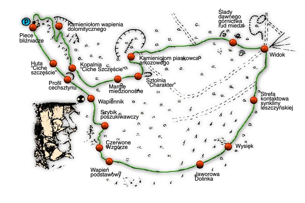
1. Didactic path “Synklina Leszczyny”
start: from the Open-Air Mining and Metallurgy Museum in Leszczyna
lengths: 2,5 km (max 1 hour)
exceedance: 95m (little)
route course: GPX (download)
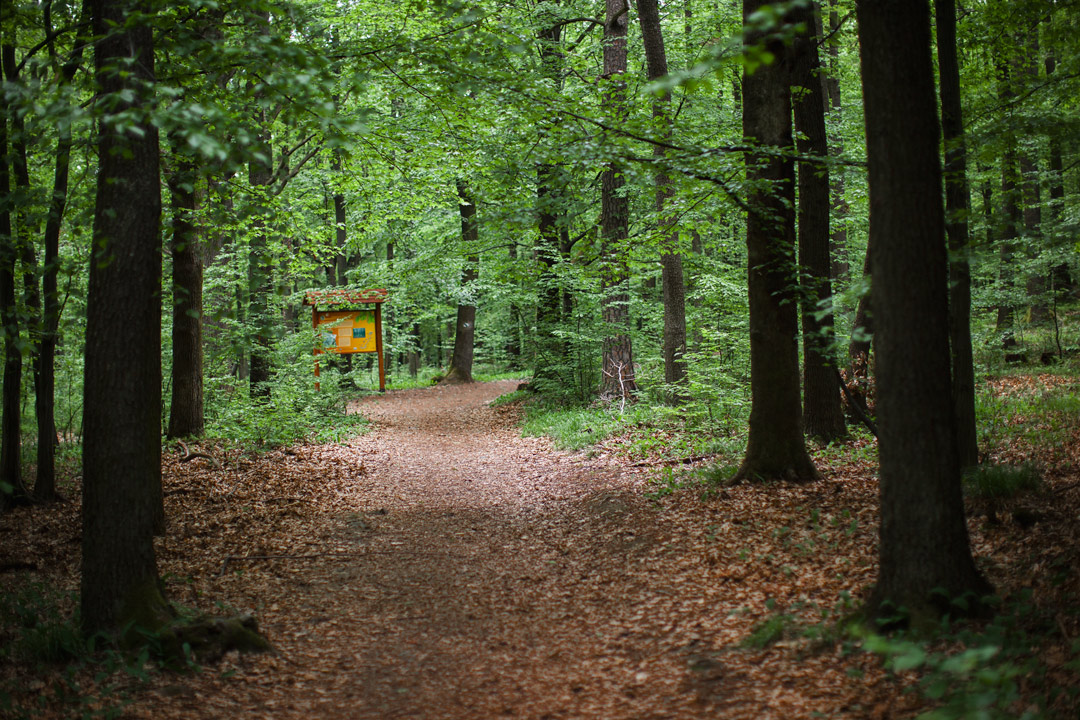
This is a relatively easy and short route that showcases the remnants of the former copper mining and metallurgy in the vicinity of Leszczyna. On the route, you will come across 18 educational boards. We also recommend reading about the geological history of this place and the phenomena that can be observed in the rock exposures. During the trip, you can also visit the Open-Air Mining and Metallurgical Museum in Leszczyna and plan to have lunch at the Karczma Górnicza located there.
More information:
Sketch map of the trail (source: Złotoryja Commune)
Photographic report from the route on the wolniej.com blog

2. Nature and geology trail “Wokół Wielisławki”
start: from Wielisław Organ in Sędziszowa
length: 2,7 km (approx. 1 hour)
przewyższenie: 167m (medium)
route course: GPX (download)
Climbing Wielisławka is a hike in the Kaczawskie Mountains that you must experience! The Wielisław Organ itself are a very popular attraction in the region. For those who would like to embark on a longer hike and explore the summit of Wielisławka, there is a nature trail that encircles the hill, with the option to reach the summit (which is also a mandatory point for the Kaczawska Crown badge). At the foot of the mountain, there is a historic mill with a restaurant and guesthouse.
Trip route:
More information:
Report from the trail on the weekendowyturysta.eu blog

3. Nature path “Dookoła Miłka”
start: from the car park in the centre of the town
length: 6,5 km (approx. 1,5 hours)
exceedance: 176m (medium)
route course: GPX (download)
This is a very charming and relatively easy trail that leads through the beautiful beech forest of the “Miłek” reserve and offers views of the surrounding meadows. The trail is marked with the name “Miłkowa droga,” and along the way, you will also find educational boards. Near the parking area, there is a very charming café.
More information:
Description of the trail with a special focus on its natural values can be found on przyrodniczo.pl

4. Wojcieszów – Dłużek – Wojcieszów
start:from the car park of the single track Dłużek (location of the car park)
length: 8,1 km (approx. 2 hours)
exceedance: 264 m (medium)
route course: GPX (download)
A very picturesque and scenic route in the vicinity of Wojcieszów in the Kaczawskie Mountains. It doesn’t have specific markings, but with the help of a map application or a printed map, you shouldn’t have any trouble following it. From time to time, you’ll also see an arrow with a sign indicating “Wieża widokowa” (“Viewing tower”). You hike up on the so-called “white trail” (which actually isn’t white at all), and you return in the vicinity of “Pod Chmielarzem” Guesthouse. On the route, you can find boards of the “Gruszka” didactic trail and interesting facts related to the former mining activity. The highest point is the observation tower on Dłużek, from which you can enjoy panoramic views of the Chełmy Landscape Park, the Kaczawskie Mountains, the Rudawy Janowickie, and the Karkonosze Mountains.

During this hike, you can take advantage of the “Gruszka” educational trail signs:
5. Myślibórz – Myślinów – Jerzyków – Myślibórz
Another suggestion within the “Chełmy” Landscape Park. The trail initially leads through the Myślibórz Gorge, then heads north towards Myślinów (you can take a shorter route by following the yellow trail or a slightly longer one by following the black and blue trails). From Myślinów, the blue trail continues to the Jerzyków colony, and the red trail returns via Chełmiec (near the palace) to Myśliborz.
start:from the car park near Myślibórz Gorge (location of the car park, in the high season for a small fee)
length: 11 km (3 hours)
exceedance: 281 m (medium)
przebieg trasy: GPX (ściągnij)
Trip route:
6.”Tourist” walking path: Myślibórz – Siedmica – Jakuszowa – Myślibórz
The route is a proposal prepared by the Paszowice Municipality, leading through picturesque and environmentally valuable areas of the “Chełmy” Landscape Park. The beginning of the trail leads through the Myślibórz Gorge and the forest to Siedmica, then through the small, secluded village of Jakuszowa, and back to Myślibórz. The trail is well-marked with traditional tourist trail markings and signs.
start:from the car park near Myślibórz Gorge (location of the car park, in the high season for a little fee)
length: 12,5 km (approx. 3,5 hours)
exceedance: 542 m (significant)
route course: GPX (download)


7. Dobków – Dłużek – Dobków
Another slightly longer walk in the Kaczawskie Mountains – to the observation tower in Dłużek, this time starting in Dobków. The trail was marked a few years ago but requires some maintenance. Despite that, you will find its markings and signposts, and with the help of a map app or a paper map, you will reach the summit without any issues. As a reward, you will enjoy the views from the observation tower and a very pleasant forest trail, which also passes through meadows. Warning, it can be muddy after rain or thaw, especially in the open terrain section.
start:from the car park near the Sudetic Geoscience Centre
length: 12,5 km (approx. 3,5 hours)
exceedance: 367 m (medium)
route course: GPX (download)
Trip route:

8. Muchów – Wąwóz Lipa – Nowa Wieś Wielka – Muchów
In the Lipa Gorge, you can encounter the famous salamanders in early spring. But even if you don’t encounter them, the trail is romantic and will reward you for all your efforts. Start from Muchów, where you can find the historic palace. Along the way, you’ll pass through Nowa Wieś Wielka, an incredibly charming and peaceful village nestled among the mountains and forests. You can shorten the route by walking through the entire village or take the full route by following the blue and then green trail.
start:from Muchów (location of the car park)
length: 13 km (4 hours)
exceedance: 255 m (little)
route course: GPX (download)
Trip route:

9. The “Leśna przygoda” (Forest Adventure) path – Nowa Wieś Wielka – Siedmica – Nowa Wieś Wielka
Another proposal in the picturesque Chełmy Landscape Park. The trail is well marked with signs thanks to the initiative of the Paszowice Commune. We suggest starting in Nowa Wieś Wielka. Along the way, you’ll encounter the beautiful and wild Siedmica Gorge (in the summer, the trail can be quite overgrown, but still visible, and the vegetation can reach waist-high). It will be a true “forest adventure”!
start:from the centre of the village in Nowa Wieś Wielka
length: 13 km (approx. 3,5 hours)
exceedance: 483 m (little)
route course: GPX (download)


10. The Trail of Stone Crosses in Choiniec
The „Trail of Stone Crosses in Choiniec in the Land of Extinct Volcanoes” was opened in 2014. It has a length of approximately 14 kilometres. The trail begins in the centre of Choiniec. It is crossed by the road from Złotoryja to Lwówek, which is why the trail is conventionally divided into a northern and southern section. It is possible to walk the northern part separately and then the southern part (or the other way round), returning to Choiniec. Additionally, thanks to the appropriate marking, you can walk the trail in both directions.
start: from Choiniec
legnth: 13,9 km (4 hours)
exceedance: 260 m (little)
11. “Scenic” Path – Kłonice – Grobla – Myślibórz – Kłonice
A long but not very strenuous walk prepared by the Paszowice Commune. You can also start from Myślibórz, but for a change from the “Tourist” trail described in point 6, we have prepared a starting point in Kłonice. There, you can climb Radogost and also see the historic palace. The route runs along well-marked and comfortable roads through Grobla (including a gorge in the “Nad Groblą” reserve), Siedmica (where there is a convenient camping spot), Jakuszowa, and Myślibórz. On the way from Myślibórz to Kłonice, you will also visit Bazaltowa, another mandatory point for the Kaczawska Crown badge.
start:from the car park in Kłonice
length: 16 km (4-5 hours)
exceedance: 765 m (significant)
route course: GPX (download)


