
The Lipa Gorge is a relatively less visited but noteworthy location in the southeastern part of the Kaczawskie Foothills. It is located in the “Chełmy” Landscape Park, north of the village of Lipa and south of Nowa Wieś Wielka. In this area, the Pogórze Upland borders the flat-bottomed depression of the Świerzawa Trench along a distinct, steeply inclined, and forested ridge with a height of about 60 metres. The direct cause of its formation was the varied resistance of rocks. Both the Pogórze Upland and the actual ridge are composed of greenstones, which are former metamorphic rocks formed by the transformation of underwater basaltic lava. They are harder and more durable than the Permian sedimentary rocks found in the Świerzawa Trench, which consist of friable sandstones, conglomerates, and soft mudstones. However, the primary cause of this situation was the presence of a tectonic fault along which the sedimentary rocks were lowered relative to the greenstone rocks. This fault was active during orogenic movements at the boundary between the Mesozoic and Cenozoic eras, approximately 70–60 million years ago, much earlier than the Sudetic Marginal Fault, which delineates the border of the Kaczawskie Foothills from the side of the Silesian Lowland.
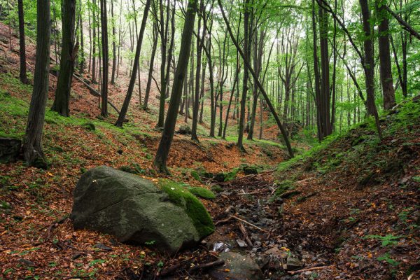
The gorge is actually a V-shaped valley
Wąwóz Lipa is actually a V-shaped incised valley formed as a result of intensified water erosion. It’s hard to believe when you look at the small stream flowing at the bottom of the valley – it seems disproportionately small compared to the depth of the valley. During dry periods, it completely disappears. How, then, was the carving of such a distinct valley form possible?
Answers should be sought in more distant times when the landscape of the Kaczawskie Foothills looked significantly different. Around 450,000 years ago, this area came under the influence of a massive ice sheet that advanced over present-day Poland from Scandinavia. Evidence of its presence includes, among other things, glacial erratic boulders composed of rocks found in Sweden and Finland. As the climate began to warm, the ice sheet started melting, abundantly feeding rivers and streams with the water flowing from it. One of these streams, originating from large ice masses on the Pogórze plateau, didn’t flow through any pre-existing valley but began carving a new erosional form. It cut into the Pogórze’s exposed ridge for several dozen meters as it emerged from under the ice.
This likely occurred in a relatively short period, on the order of a few thousand years. Carving the valley during the ancient glacial period doesn’t mean that it remained unchanged in later times. In subsequent cold periods, rock weathering processes were actively at work, mainly due to the freezing of water in cracks and fissures in the rock. Detached fragments of greenstones didn’t stay in place but, following the slope of the terrain, moved downward, forming extensive deposits at the base of the rock walls. These can be observed today on both sides of the valley, below the rising walls, alcoves, and towers formed by the greenstone slopes. Moreover, these rock outcrops are among the most spectacular in the entire Land of Extinct Volcanoes, reaching heights of up to 15 metres. While walking along the tourist trail at the bottom of the Lipa Gorge, it’s also worth noting the presence of glacial erratic boulders – the best evidence of the connection between the valley and the Scandinavian ice sheet.
Nature reserve
The nature reserve “Wąwóz Lipa” encompasses the northern, sometimes rocky slopes of the Nysa Mała Valley, along with one longer side valley distinguished by the presence of rock towers, alcoves, and walls reaching heights of up to 15 metres. In the bottom of this side valley, especially in the upper section, glacial erratic boulders are abundant, including those distinguished by the reddish color of Scandinavian red granite, with diameters up to 1 metre.
The nature reserve was established in 1996, covering an area of 54.7 hectares, and later expanded in 2002 to its current size, encompassing 101 hectares. Within its boundaries, there are several plant communities. On steep slopes, there are thermophilic submontane oak forests and service-oak forests with wild service tree. The oaks appear in a stunted form with twisted branches. In the western part of the reserve, there is a submontane acidophilous oak forest with the dominant sessile oak, mixed with birch and pine. The scree slopes are covered with a maple-linden forest, featuring lime, sycamore, and pedunculate oak. The habitat’s humidity favors a rich understory, with the presence of orchids, mezereum, and Turk’s cap lily. Along the Nysa Mała River, there are ash-elm riparian forests. In the reserve, over 270 plant species have been recorded, including 22 protected species. In terms of fauna, the most valuable species is the spotted salamander, which forms a numerous population in the reserve.
Walking route:
Description: Piotr Migoń


